Marsh Bird Surveys
Marshbird Webinar for Volunteers
The marsh bird survey focuses on secretive nesting marsh birds including: pied-billed grebe, American bittern, least bittern, black rail, king rail, Virginia rail, sora, common moorhen, and American coot. This marsh bird monitoring protocol is adapted from the Standardized North American Marsh Bird Monitoring Protocols (Conway 2009) and very similar to that used in the 2nd Pennsylvania Breeding Bird Atlas (Lanzone et. al. 2006). Because often under-detected marsh birds, respond to playback during the nesting season, these surveys can improve our understanding of the statewide distribution and relative abundance of these rare birds (Conway 2009).
The information collected will promote conservation efforts for this declining habitat and the birds and other wild species that depend upon it. Other rare non-target birds may also be encountered including; Wilson’s snipe, sedge and marsh wrens, American woodcock and alder and willow flycatchers.
Marsh bird surveys will be conducted on wetlands across the state during the 2020 breeding season. The PGC will concentrate special effort on surveying the largest wetlands during the 2020 season. We’re looking for volunteers to helps us with all the other wetlands in Pennsylvania. Data collected on any wetland will benefit marsh birds by improving our understand or their abundance and distribution. Your participation is needed!
Surveys should be conducted between May 1st and June 15th either in the morning or the evening, when marsh birds are most detectable.
Each survey point should be replicated three times! Vocalizations usually peak in the hour surrounding sunrise and sunset (Conway 2005). Morning surveys can be conducted anytime from first light (30-45 minutes before sunrise) to 3 hours after sunrise. Evening surveys should be conducted from 3 hours before sunset to dark (30-45 minutes after sunset). Please do not conduct the surveys outside the designated times. After reading the instructions, if you have any questions about the protocol, please don’t hesitate to ask for clarification. Please understand the details before expending time and effort conducting surveys.
To improve surveys; familiarize yourself with the various vocalizations of marsh birds likely to be encountered, both target and non-target species. Examples are on the audio files available for these surveys. There are also internet resources for reviewing marsh bird vocalizations including the North American Marsh Bird Monitoring Program.,
https://www.cals.arizona.edu/research/azfwru/NationalMarshBird/.
The marsh bird survey will be conducted playing a standard audio file. Participants will broadcast the file: if you conducted marsh bird surveys for the atlas the equipment is similar, but as technology has advanced and smartphones have become more utilitarian it can cover several of the earlier items needed. The survey file on your smartphone will collect the data, your survey location and play the file. In addition, you’ll need a speaker to broadcast the sound file loud enough for the calls to be heard across the marsh.
Some examples from the North American Marsh Bird Monitoring Program,
https://www.cals.arizona.edu/research/azfwru/NationalMarshBird/ under field methods then broadcast equipment. PGC staff are using smartphones and speakers capable of producing loud, non-distorting playbacks birds hearing and responding to calls. I’m using an Ultimate ears Megaboom 3 speaker; it’s loud, water resistant and seems to hold a charge well for multiple surveys.
To conduct a survey, first contact the marsh bird survey coordinator, Patti Barber, MarshBirds@pa.gov, to register as an observer, evaluate survey point locations and wetlands, listen for birds, and submit your data.
Survey locations can be identified on the marsh bird survey map application, available from coordinator with observer registration. Additional wetland sites can be found on the map application.
When selecting a survey point location, please:
- See map of wetland patches
- Place observation point on map and add observer to indicate you’re committed to conducting the survey
- Review data form and protocol
- Conduct the survey
- record your observations while conducting survey in real time or if necessary, use a datasheet and submit manually on the marsh bird survey map application.
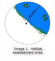
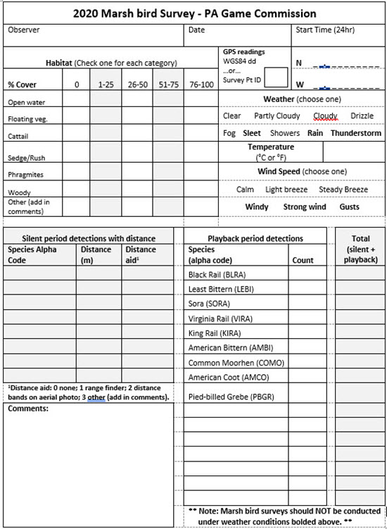
As soon as you arrive at your survey point, record all the supporting data (e.g., weather, habitat, etc.) on the data sheet (survey page 2 or Appendix 2). Rapidly assess habitat in a semi-circle area with a radius of
100 meters in front of the survey point (Image 1). This should be a first impression that only takes a few seconds to determine, not an in-depth analysis.
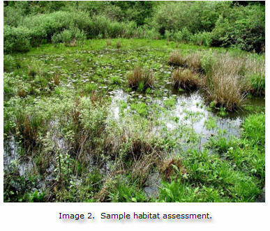
Image 2 is an example of vegetation coded at a wetland in the habitat section of the data sheet (Appendix 2).
- Open water- 1-25%
- Floating Vegetation 25-50%
- Cattail 1-25%
- Sedge/Rush 1-25%
- Phragmites 0%
- Woody 1-25%
- Other 25-50%
For more information on wetland plants visit
http://plants.usda.gov, for examples of habitat components (Appendix 3).
Play the audio file (top of page 4 on survey form). The observer should be outside of a vehicle and far enough from the playback equipment to avoid interference from the equipment itself. speakers should be pointed directly at the wetland and least 3 feet above the ground with the volume as loud as possible without distorting the calls. The survey track begins with the spoken word “start;” and ends with “stop.”
Do not stop the track at any time during the survey. Focus on vocalizations that are not part of the recording. Don’t forget to watch for birds too. Marsh birds sometimes approach a sound or intruder in their territory by walking a distance before vocalizing. Keep track of the location of different vocalizations and possible responses between different birds. Be careful to distinguish recorded from natural sounds and minimize other noises or quick movements.
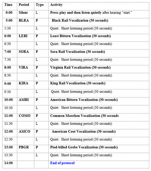
The track begins with
five minutes of silence (the “silence period”, survey page 4), followed by a series of vocalizations of marsh bird species (the “playback period”, survey page 5) (Appendix 1). Record individual birds heard during the silent period and during the tape playback period in the appropriate columns on the data sheet (Appendix 2).
Estimating distance to each focal bird.
During the 5-minute silence period, surveyors should estimate distance to each bird when the bird is first detected since birds may approach the call broadcast during the survey, which violates an important assumption of distance sampling. Like all measurements, estimating distance to individual birds during surveys includes measurement error. However, training surveyors to estimate to distance to calling marsh birds can decrease bias. Methods for improving one’s ability to estimate distance include: 1) tying surveyors flagging at regular intervals away from each survey point in each cardinal direction, or 2) carrying aerial photos of the marsh with 50m-, 100m-, and 200m-radius circles drawn around each survey point. Estimating the distance to some individual birds will involve a lot of uncertainty (i.e., estimating distance to birds 5m from the surveyor is much easier than estimating distance to birds that are >100m away).
Surveyors are encouraged to use a range finder to help them determine the distance to specific landmarks surrounding each survey point, which will help estimate the distance to calling marsh birds. Surveyors should enter on the datasheet and in the database which of the following distance estimation aides they used: 1) unaided, 2) distance markers, 3) range finder, 4) range finder and maps, or 5) maps or distance bands drawn on aerial photo.
Survey Method for selected point count locations:
Each survey point should be visited and surveyed three times, each two weeks apart, between May 1 and June 15.
Negative data are important in learning about the statewide distribution, habitat preferences, and relative abundance of breeding marsh birds in Pennsylvania. If you detect no marsh birds during a particular survey, please fill out the data sheet entirely, and write “no birds detected” in the comments section.
In addition, if a wetland marked on the map is gone or unsuitable for nesting marsh bird species, please indicate that by choosing the appropriate type of observation symbol on marsh bird on the map application, record any details in the comments section and submit this data.
At the end of the survey, record the number of
different individuals of each species you detected as the totals on the data sheet. When conducting surveys, be smart and stay safe:
-
Respect private property (do not trespass). Look for a way to survey from a public road, obtain permission from the landowner or move on to another wetland.
-
On public lands let managers know what you’re doing, avoid surprises and minimize interruptions
- Avoid busy roads and any unsafe conditions
- Carry a reliable flashlight for early morning and evening travel and extra batteries
- Travel with a partner or tell someone where you are going
- Plan ahead, checking maps for driving directions and best access points
Marsh bird surveys must be run under satisfactory weather conditions, inappropriate weather conditions reduce the chances of hearing or seeing marsh birds, surveys should not be conducted during steady rain, thunderstorms and windy conditions. If during any of the surveys the weather briefly changes to any of the unsatisfactory conditions, you may pause the survey and continue when the weather event subsides or passes. If it lasts for a long time you may want to continue the surveys another time.
Any extra information should go in the comments section of the data sheet (Appendix 2), such as:
- unusual vocalizations heard and not identified (do your best to describe or, if possible, record these),
- interruptions or excessive noise
- emergent wetlands no longer in designated area
- multiple birds counter singing, agitated behavior, adults carrying food, recently fledged young or adults feeding young, and
- any birds that respond from an adjacent wetland rather than the one you are surveying. When in doubt, please include the details.
After completing your surveys, please submit your marsh bird data, even if you did not have any marsh birds or the marsh was not suitable for surveying, using the marsh bird survey map application. Double check to make sure everything is completed. Confirm your marked survey points on the GIS map coordinate with your observations. Please submit your data as you complete each survey, but no later than July 15th.
Thank you for your hard work and attention to details! Contact the marsh bird coordinator with any questions at
MarshBirds@pa.gov
Reference
Conway, C. J. 2009. Standardized North American Marsh Bird Monitoring Protocols, version 2009-2. Wildlife Research Report #2009-02. U.S. Geological Survey, Arizona Cooperative Fish and Wildlife Research Unit, Tucson, AZ.
Lanzone, M. J., R. S. Mulvihill and T. M. Miller. 2006. 2nd Pennsylvania breeding bird atlas marsh bird survey protocols. Powdermill Avian Research Center, Rector, Pennsylvania. 22 pp.
Appendix 1. MARSH BIRD AUDIO TIME CHART
Marsh bird audio time chart coincides with the marsh bird survey audio file and data sheet. During each “period” record the number of individuals seen or heard on the data sheet. The “type” in the chart below refers to L – Listening, or P – Playback.
Appendix 2. DATA SHEET print datasheet
Appendix 3. EXAMPLES OF WETLAND VEGETATION
